The Probable Storm
I've lived in this region my entire life. I've seen four or so hurricanes, some tropical storms, and my share of long-lasting Nor' Easters. I've also sat on the shore waiting for one highly-touted storm or another, and getting to see little more than gray skies and choppy seas. It's as if the coastline was formed in defense of storms and we live at the apex of that defense.
That is not to say it is not possible. It is, although NYC tends to be on the soft side of storms (although not the dry side -lookout Jersey) that do hit. The likely paths of these storms are a recurve back out to sea (often hitting Cape Cod, Maine, Nova Scotia) as the systems get pulled into a north-east moving low pressure or pushed off coast by a mid-continental high. These are the likely scenarios. But, and it is early, it seems to me that there are indications that this storm could actually hit our area this weekend, maybe Saturday evening/Sunday morning. Here's why I think it may hit the metro region as a hurricane.
Sea surface temperatures well above eighty degrees F as far north as Delaware.
These high surface temperatures keep a storm going strong as it travels north.
An envelope of moisture, which keeps dry air from entering the storm, and low to moderate wind shear. High wind shear tears at the structure of a storm.
The most common computer models are generally in agreement. The red path, the GFS model, has prominence amongst the weather geeks.
Here we have the paths of similar storms in the month of August over 150 years. This is useful as it generates a sense of historical probability, if not predictability.
Here is this evening's weather map. It shows a weak high pressure over Louisiana, and a low passing over Canada and the Midwest. Normally I would say this low pressure would pull the system out to sea with it as is often the case.
But that low pressure system seems weak and may actually help to pull the system towards the coast as the low pressure lifts further north into Canada.
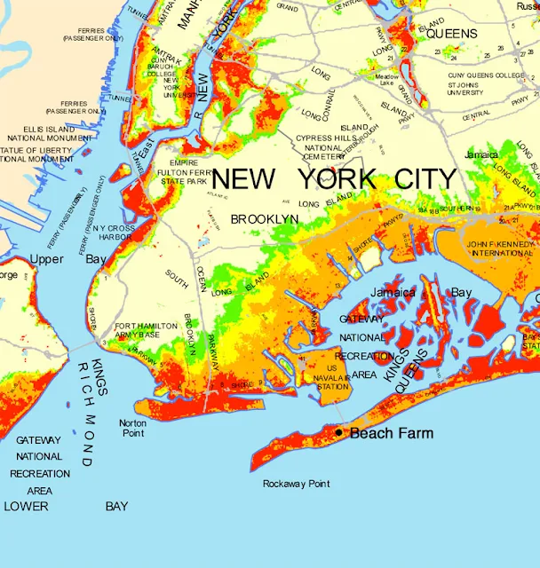
This is a map of storm surges for Brooklyn, some of Queens, Manhattan, and Staten Island. Red indicates the affected land area at high tide from the storm surge of a category 1 hurricane should it hit squarely in our area. The orange, a category 2 storm. Category one and two storms are the most likely based on the history of storms to hit the region. Category 4 and 5 are extremely unlikely because the water temperatures simply cannot sustain that kind of a storm.
It's too early to make an accurate prediction, but my instinct is to watch this storm closely as conditions are as favorable as they could be for the storm to hit Long Island or even NYC. It is a large storm with a larger than average tropical storm force wind field, so one way or the other, NYC will feel the effects of this storm. The beach farm, located on the map, will also feel the effects. Wind blown plants, heavy rains, and possible salt water flooding depending on where the storm goes and its intensity as it does so.
Update 8/25/11 AM: I feel more confident in saying that we should batten down the hatches. Should the storm path bear down us, bring in what is loose. If you have a car, try to get it in a garage, or at best park it away from trees. Tie up your trash pails to railings. Stake garden plants firmly or allow them to lie on the ground. Most will recover. It is hard to imagine this as a leaf-stripping event, but things will fall. Stay inside. Have a hurricane party.
Thanks to Wunderground.com for making weather maps accessible.


I'm so worried that this storm is going to cause havoc on my garden. Its going to easily snap all the tomato plants. Argh. I'm going to put all the potted plants in the garage in hopes that I can save them.
ReplyDeleteYour tomatoes are pretty flexible, but the wind may push them to the ground. If we do get the storm, it's worth putting inside what you can.
ReplyDeletethanks, frank. this is really really interesting.
ReplyDeleteSupergeek! No, really, it was very interesting. Barring catastrophe, of course, I am looking forward to a little weather.
ReplyDeleteOh thanks Frank keep me posted as we are traveling to RI on Saturday and back to NH on Sunday. My take is Sat is okay and Sunday we should be driving out of the storm before it hits our area on Sunday...do you think?
ReplyDeleteLove OX's
That's a plan! Leave early, I'm predicting an earlier landfall than Sunday afternoon!
ReplyDelete