Camp Hero, Part 2
As a kid and into adulthood, my family or I would often make the pilgrimage to Montauk, way past the hoity absurdity of the *hamptons. We would land at Hither Hills State Park, get there early for the spot on the top of the bluff. My grandfather used to cook pasta on the grill, and make perk coffee in the evening. We'd stay till dark, sometimes after, then make the long drive home.
Sometimes we'd hit the lighthouse. In between was a few miles of beach front condos, a small town serving the tourist, and then woodlands, dense woodlands all the way to the light. This was drive through area, my family not being much for hiking, on the way to and from Montauk Point. As it happens, then, I never knew much about it other than it was shaped by the sea around it and the glaciers before it. Not until Camp Hero, did I begin to see how it is different from the Long Island I know, or even Hither Hills just a couple of miles west.
 On our way to the central parking lot, where we were to begin our hike, I noticed these peculiar wooden planks apparently shoring up the stream sides. After the first one, I saw them all over the place. My first thought was, how long will this work? My second thought was, I can't believe there are so many streams here.


 I was rather enthralled with the silver coloration of many of the trees. Was it the effect of the salty sea, was it the species, or lichen?


We were on the white marked trail, which I remember well from the mushroom maze. It's also known as the Paumanok Path, which terminates at the sea in front of the Montauk lighthouse. On our way to the central parking lot, where we were to begin our hike, I noticed these peculiar wooden planks apparently shoring up the stream sides. After the first one, I saw them all over the place. My first thought was, how long will this work? My second thought was, I can't believe there are so many streams here.
After all, I grew up on dry, sandy Long Island. Now there are pockets of wet areas, kettles and swamps or streams as around Nissequogue or Peconic. But this seemed wholly different, it was elevated quite a bit above sea level and the streams seemed to cris-cross the landscape. We had just had record rains, so maybe we're seeing water where typically it may have only been sporadic. But then, these old planks told a different story, and so did all the areas with skunk cabbage. It was only later on the beach when I would fully understand the hydrology of this area.
It was unusual to see plane trees, city trees, until I reminded myself that this is an utterly human landscape, a military post. Along the streets, and some trails, plantings.
 I was rather enthralled with the silver coloration of many of the trees. Was it the effect of the salty sea, was it the species, or lichen?
Small tree in silver.

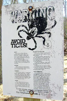
This, of course, is tick country. I found this old sign amusing -its pre-deer tick, click on it to read. My brother is hyper tick worried, so going at winter's end was his idea of tick free. Of course, that's only partly true. When we were kids we bushwacked through the thicket only picking up a tick or two in ten years. Now it's as if there's an army.
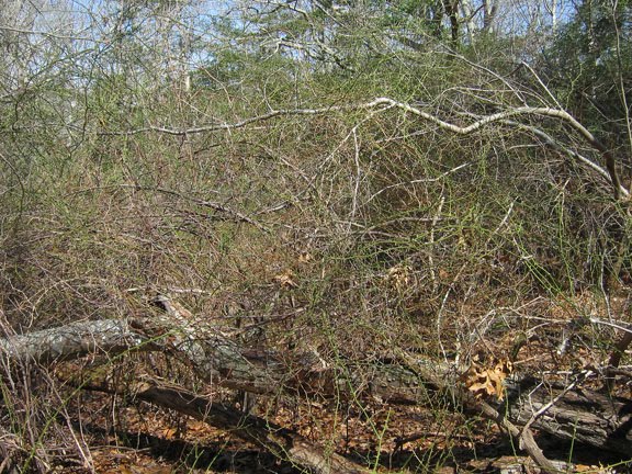
There are many patches of greenbrier, dense and impassable.
From the central parking location, near the radar, we headed out. First on a paved road, Col. John Dunn Rd., then making a right on Old Montauk Highway, and finally turning onto the trail portion of the Paumanok Path. We wanted to make a loop, landing back near the radar at trail's end.
I saw three forest communities on the woodland hike and I was amazed by the diversity on such a small parcel of land. All of these forest communities are somewhat rare, given their dependence on a very specific set of conditions. The higher elevation of this area protects these communities from the salt spray, which can limit species and canopy heights.
The first was Coastal Oak-Holly, dominated by oaks, but also including tall, mature holly trees.
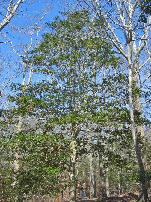 Without the canopy of leaves, its easy to see the full holly. It's a beautiful tree that I think is rarely used well in home landscapes. Always planted like a shrub, too close to the house.
The bark is smooth, pleasantly colored, with nice eyes.
 Of course, its leaves are sharp, which discourage deer browsing when mature, although the word is that the abundant deer are taking these out while still young.

We moved into an area with a stream, crossing over a couple of foot bridges.

Skunk cabbage was making an appearance.

This one with a moss belt.

Streams with mini waterfalls are just a bit uphill. I would have loved to play around this as a kid and spent the most time here, now.
 The water was brown with tannin and its bed was like beach sand.

We soon found ourselves in a Coastal Oak-Laurel forest, magnificently illustrated by this laurel-oak bond.

The laurel bark is quite attractive, reminding me of cedar or yew trees.
 This laurel understory reminded me of the Oak Laurel forest at Weir Farm, but also of the laurel woods on the north shore of Long Island.
Moss and laurel.

You will notice a few glacial erratics lying around, this being a morainic landscape.
 But this area, after a little investigation, turned out to be an erratic dump -brought in by trucks from the military post, not the glacier.

The changeover from Coastal Oak Laurel to Coastal Oak-Beech was dramatic as we headed north on the Paumanok Path. The darkness of the evergreen laurels on one side of an imaginary line contrasted strongly with the brilliant silvery bark of the beech trees on the other. The beech trees grow on the north facing slopes, possibly the reason for the dramatic changeover.

Beech trees are wonderful trees. Great bark, excellent summer canopy, ghostly leaves through winter clinging to its branches. Just don't plant one near your sidewalk.
 You can always tell a beech tree by its network of surface roots.
 In the beech forest I discovered the convergence of two streams -not something I've seen much of on Long Island. At the convergence, the stream flows northerly.

Just south, I see the terminal point of one of the erosion control contraptions.
One hundred feet to the east is the roadway. We exit, walking toward the radar. At the gate, we get onto the bridal trail, a horse path, every now and then leaping over mucky zones.
Thanks for the tour!
ReplyDelete